I got an early morning e-mail from Bob Cook the weather router confirming that the weather was still good, and we were OK to go.
Here are some map snippets that show a couple of different views of the intended route for the day.

It's about a 52 nm run, but it's not the distance that gets you on this one, it's the exposure.
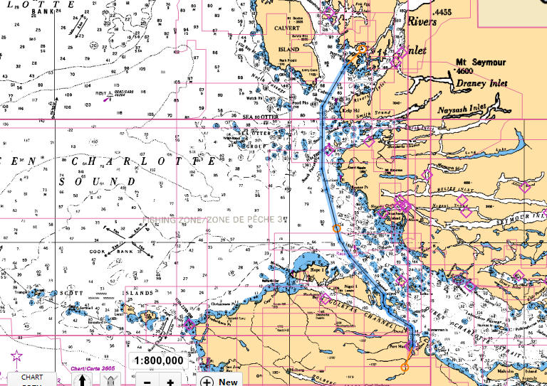
Here's a slightly different perspective on the route.
Notice something missing on the left side of the route - namely land masses.
Land masses are what break up the ocean swells and create protected waters.
On this run the boat is vulnerable to whatever the ocean decides to throw at you.
But Bob Cook the weather guy said we were good to go, so go we did.
We pulled out about 6:30 AM.
The run was not as smooth as I had hoped it would be.
We did get bounced around a bit.
And unfortunately wife Lisa did get seasick.
And Bina was terrified - I was told.
I was upstairs, they were downstairs for the whole run.
It did give me comfort to know that even though it was a little bouncy that it was not going to get worse.
The worst fear on this kind of run is getting part way out there, past the point of no return, and then getting slammed.
But that didn't happen today, we just bounced our way to the destination, Fury Cove on Penrose Island.
Here is a detailed view of Fury Cove where we anchored.

We arrived into Fury Cove at about 1:30 PM.
Distance covered thus far was 483 nm, over halfway now for sure.
There were about 5 or 6 other boats already anchored there.
I am not used to anchoring around other boats, since in our home waters we usually have the anchorage to ourselves.
I set the anchor once and ended up much too close to one of the other boats.
I had to pull the anchor and then set again, this time coming out in a satisfactory location.
 |
| At anchor in Fury Cove |
I thought anchoring was tight when we got there.
Within the next hour 7 boats from the Waggoner Flotilla arrived (one was already there) and each of them also had to find a place to set their anchors.
I was watching them and one of the larger boats, about 55' I think, set and reset at least 5 times before being satisfied with his position.
Eventually they all got settled in, and by night fall we had about 15 or 18 boats anchored in the cove.
Here are some photos from Lisa's phone.
 | |||
| Midden beach |
It looked like white broken shells to us, but it was clear when we got closer that it was made up of more than just shells.
Here is what Wikipedia has to say about "midden beaches:"
A midden (also kitchen midden or shell heap; from early Scandinavian; Danish: mødding, Swedish regional: mödding) is an old dump for domestic waste. which may consist of animal bone, human excrement, botanical material, vermin, shells, sherds, lithics (especially debitage), and other artifacts and ecofacts associated with past human occupation.
The word is of Scandinavian via Middle English derivation, and is today used by archaeologists worldwide to describe any kind of feature containing waste products relating to day-to-day human life. They may be convenient, single-use pits created by nomadic groups or long-term, designated dumps used by sedentary communities that accumulate over several generations.
These features, therefore, provide a useful resource for archaeologists who wish to study the diet and habits of past societies. Middens with damp, anaerobic conditions can even preserve organic remains in deposits as the debris of daily life are tossed on the pile. Each individual toss will contribute a different mix of materials depending upon the activity associated with that particular toss. During the course of deposition sedimentary material is deposited as well. Different mechanisms, from wind and water to animal digs, create a matrix which can also be analyzed to provide seasonal and climatic information. In some middens individual dumps of material can be discerned and analysed.


Curious thing, I asked one of the skippers from the Waggoner Flotilla where they were headed next, and he said he didn't know. He said he was just following the group, and wherever they went, he went. I would not be comfortable navigating, or in this case not navigating, in this manner. I like to know where we are headed well before we go there.
No comments:
Post a Comment