Friday, July 22, 2016

Seattle to Ketchikan Day 23

Thursday May 26

Our destination for today was about 73 nm away - so a pretty long run.

Here is a map snippet that shows the route:


After a quick shore excursion for Bina we stowed the raft and pulled anchor at about 8:30 AM.

When we pulled out into the channel we immediately encountered unfavorable currents, which was discouraging since we had such a long way to run today.  But it is what it is.  I could run at a higher RPM in order to gain some speed, but then the fuel burn goes up exponentially.

We had made the joint decision to skip Bishop Bay Hot Springs this trip.
We stopped there last year and really enjoyed it.
But it is pretty far out of the way, and in truth, we were both getting very eager to be back home.

We slogged on and on for the day, and actually had rain squalls for a good portion of the day.
Had to use my windshield wipers for the first time on this trip.

We pulled into Lowe Inlet about 6 PM and found no other boats there at that time.
A couple of boats came in later.

Here is a map snippet that shows Lowe Inlet and Nettle Basin.


We went past Pike Point and anchored in that little nook just below the anchor symbol on the chart.
The guide books say that the primo anchoring spot is directly in front on Verney Falls, where you can let the strong current keep you pointed towards the falls in any stage of the tide.
I thought about anchoring there, but I was concerned that getting in and out of the raft for our shore excursions might be difficult with that much current flowing past the boat.

Our mileage to this point was 660 nm.

We got the raft ready and took Bina to shore.
It was a nice large beach and Lisa let her run loose for quite a while.

Shortly after we got back to the boat we were sitting there in the cabin and Bina started growling.
There was a large cruising yacht anchored nearby and 4 or 5 people had run up on the fore deck with cameras and binoculars, and that's what Bina was growling at.
We looked over to the beach where were just had walked Bina and saw a lone wolf prowling the beach.


Since we were in Canadian waters I was not allowed to carry any firearms on board, so I was a little concerned about our need to take Bina to shore again in the morning before we left.
I resolved this by taking an air horn, and a flare gun, neither of which were needed since we did not see the wolf again after that initial sighting.

Here are the other 2 boats that came in while we were there.


Tomorrow - Prince Rupert!

Wednesday, July 20, 2016

Seattle to Ketchikan Day 22

Wednesday May 25

We pulled away from the dock at Shearwater and moved over to the fuel dock at about 7:30 AM.
I knew the fuel dock did not open until 8:30 AM, but I also knew that several of the boats in the Waggoner Flotilla also needed fuel, and I didn't want to be in line behind them.

I took on some fresh water while we waited for the fuel dock to open.

Here is the route for the day, approximately 50 nm.


This route bypasses Milbanke Sound, for the most part, by way of going through Reid Passage.
You can see Milbanke Sound on the bottom left of the screen shot.
Milbanke Sound is pretty exposed so it can be very rough.
The approach to the turn off to Reid Passage is somewhat open and we were just starting to roll a bit before I made the turn.
Lisa called me on the intercom and asked if it was time for her to take a Dramamine.
I told her we'd be in calm waters in less than 15 minutes, and we were.

Here is a closer look at Reid Passage itself.


And here is a closer look at Bottleneck Inlet.


The route through Reid Passage is somewhat circuitous, and is certainly shallow and narrow.
But if you pay close attention to your navigation and to your depths, it is easily handled.
We had no issues.

We arrived at Bottleneck Inlet at about 3:30 PM, and dropped anchor.
We had the inlet to ourselves.
586 nm covered to this point.

Here are just a few pictures from this very scenic and serene area.


I have mentioned our new Torqeedo electric kicker for the raft a few times, but not sure I have ever included a photo of it, so here it is.


Doesn't look much like a traditional kicker, does it?

We have found it to be a good fit for us for a number of reasons.
It breaks down into 3 easily handled components, so it is very easy to put on and off the raft.
It is very quiet, (although it does whine a bit) and emits no smoky fumes.
It is easily recharged between shore excursions, and we don't have to carry mixed gas.

On the disadvantage side I would have to add these comments.
It is much slower than the old kicker.
It doesn't have enough range for a very long shore excursion.
With the old kicker we'd just throw a 2 1/2 gallon jug of fuel in the raft and we'd be good for most of a day.  But with this one it needs to be recharged fairly often.

We are on the home stretch now, with only one more stop before Prince Rupert.
We enjoy being on the boat, but we are both anxious to get home at this point.

Sunday, July 10, 2016

Seattle to Ketchikan Day 20

Monday May 23

One is never sure when one can make the Queen Charlotte Sound crossing, so I waited until we were part way across and then called ahead to Shearwater to make reservations.  Once again I knew the Waggoner Flotilla was headed there as well, so I wanted to make sure we had a reservation.

Here is the intended route for the day, up Fitzhugh Sound, and around Denny Island, and into Shearwater Resort.  It is mostly protected waters, so I had no concerns for the weather.  We had stayed at Shearwater last year and really enjoyed it so we planned to spend at least 2 nights there.


Distance was about 51 nm.

Here is a link to Shearwater's website.

Shearwater Resort and Marina

We pulled anchor about 8:30 AM, well before any of the Waggoner Flotilla boats, and headed out.
No particular problems, but the bottom here is sticky mud, which made my newly cleaned anchor locker look like someone had used it for a rest room.  Enough said.

As we headed up Fitzhugh Sound I knew the Waggoner boats were behind us.   I could hear them on the VHF radio.

We were cruising along just like every other morning, and that's when the drama began.
You just never know what's going to happen on the water on any given day.

One of the boats in the Waggoner Flotilla was a 60 footer called "Just (barely) Gettin' By."
I heard him call the Canadian Coast Guard and report that they had a medical emergency - his sister had just passed out.

One of the other boats in the flotilla was skippered by a retired orthopedic surgeon, and his boat was fast, 30+ knots fast.
They transferred the patient to his boat, and a Canadian Coast Guard fast rescue boat came by to escort them to Bella Bella, the nearest place with an emergency medical facility.  My new AIS display confirmed they went past me at over 30 knots.  I wish I had had time to take a picture, but I didn't know they were coming until they were almost past me.

I played a brief but hopefully helpful role in the drama as the Coast Guard could not communicate directly with the doctor's boat, so I relayed communications for a few minutes.

Here is a blurb about Bella Bella from Wikipedia:


Bella Bella, British Columbia

From Wikipedia, the free encyclopedia
Not to be confused with Bella Coola, British Columbia.
Bella Bella
Waglisla
Bella Bella from the water
Nickname(s): The Rock
Bella Bella is located in British Columbia
Bella Bella
Bella Bella
Location of Bella Bella in British Columbia
Coordinates: 52°09′43″N 128°08′42″WCoordinates: 52°09′43″N 128°08′42″W
Country  Canada
Province  British Columbia
Area code(s) 250, 778

Bella Bella
Bella Bella, also known as Waglisla, is the home of the Heiltsuk and is an unincorporated community and Indian Reserve community located within Bella Bella Indian Reserve No. 1 on the east coast of Campbell Island in the Central Coast region of British Columbia, Canada. Bella Bella is located 98 nautical miles (181 km) north of Port Hardy, on Vancouver Island, and 78 nautical miles (144 km) west of Bella Coola. The community is on Lama Passage, part of the Inside Passage - a transportation route linking the area, and northern British Columbia as well as Alaska for marine vessels carrying cargo, passengers and recreational boaters from the south coast.
...to the Heiltsuk, Bella Bella forms a national capital of sorts to an unceded traditional territory of 16,658 square kilometres.
Founded between 1897 and 1903, Bella Bella is located on Campbell Island.
Originally styled New Bella Bella to distinguish it from "Bella Bella", the community's official post office name for some time was Waglisla, meaning "river on the beach" in the Heiltsuk language. Old Bella Bella, the Heiltsuk village site that is located south of the current village was known as Bella Bella. As it grew, a post office was located in the store. When the Heiltsuk relocated their settlement to the north, the post office, and the name Bella Bella, moved - first to the store in the BC Packers Cannery, then to the village of Shearwater. The post office name was retained while moving location several times. This is a source of confusion and the reason 'Bella Bella' sometimes appears on Denny Island rather than Campbell Island on some Provincial maps.

Here is a map snippet that shows the community of Bella Bella, and it's geographical location in relation to Shearwater.   Bella Bella is circled in the upper left, and Shearwater is on the lower right.


I have since become friends with the doctor who took the patient to Bella Bella.
I believe she recovered fully and flew home from there.

The other more locally oriented drama this morning was that Lisa called me on the intercom and informed me that Bina had eaten a half a cube of butter!

About 3 PM we pulled into Shearwater.
Our mileage completed thus far was 535 nm.

Another drama was playing out just as we were getting settled into our slip at Shearwater.
A 50'+ boat was coming into Shearwater at about the same time we were and hit a rock less than a mile from the resort.

Shearwater has a ship lift and they pulled him out of the water right away (I'm sure at great cost.)
They left the boat in the slings over night and I went up there the next morning and took a few shots of the props.

Port prop

Starboard prop
I learned later on from the owner's brother that they hit so hard that the port shaft was bent and the impact pushed the port engine off its mounts.

The owner had a spare set of props on board, so they took the port prop off, put a new prop on the starboard side, and relaunched.  He ran the boat back to Sydney BC on one engine.
Postscript - his wife says she won't go out on the boat with him any more, so he is selling it!

Here are some more pictures from our stay in Shearwater.


Gee, they didn't have a sign welcoming the Faraway to Shearwater.


I told Lisa if we win the lottery then I'm going to buy a Nordhavn, like this one.
Then I could run from Ketchikan to Seattle, and back, without having to stop for fuel.


Catch up on laundry, groceries, e-mail, bills - it's getting to be a routine now.

We spent 2 nights here, and then it was time to move on.


Saturday, July 9, 2016

Seattle to Ketchikan Day 19

Today was the day to cross Queen Charlotte Sound.

I got an early morning e-mail from Bob Cook the weather router confirming that the weather was still good, and we were OK to go.

Here are some map snippets that show a couple of different views of the intended route for the day.


 It's about a 52 nm run, but it's not the distance that gets you on this one, it's the exposure.


Here's a slightly different perspective on the route.
Notice something missing on the left side of the route - namely land masses.
Land masses are what break up the ocean swells and create protected waters.
On this run the boat is vulnerable to whatever the ocean decides to throw at you.

But Bob Cook the weather guy said we were good to go, so go we did.

We pulled out about 6:30 AM.

The run was not as smooth as I had hoped it would be.
We did get bounced around a bit.
And unfortunately wife Lisa did get seasick.
And Bina was terrified - I was told.
I was upstairs, they were downstairs for the whole run.

It did give me comfort to know that even though it was a little bouncy that it was not going to get worse.
The worst fear on this kind of run is getting part way out there, past the point of no return, and then getting slammed.

But that didn't happen today, we just bounced our way to the destination, Fury Cove on Penrose Island.

Here is a detailed view of Fury Cove where we anchored.


We arrived into Fury Cove at about 1:30 PM.
Distance covered thus far was 483 nm, over halfway now for sure.

There were about 5 or 6 other boats already anchored there.
I am not used to anchoring around other boats, since in our home waters we usually have the anchorage to ourselves.
I set the anchor once and ended up much too close to one of the other boats.
I had to pull the anchor and then set again, this time coming out in a satisfactory location.

At anchor in Fury Cove

I thought anchoring was tight when we got there.
Within the next hour 7 boats from the Waggoner Flotilla arrived (one was already there) and each of them also had to find a place to set their anchors.
I was watching them and one of the larger boats, about 55' I think, set and reset at least 5 times before being satisfied with his position.
Eventually they all got settled in, and by night fall we had about 15 or 18 boats anchored in the cove.

Here are some photos from Lisa's phone.

Midden beach


The cruising guide books all refer to this as a "midden beach."
It looked like white broken shells to us, but it was clear when we got closer that it was made up of more than just shells.

Here is what Wikipedia has to say about "midden beaches:"

A midden (also kitchen midden or shell heap; from early Scandinavian; Danish: mødding, Swedish regional: mödding) is an old dump for domestic waste. which may consist of animal bone, human excrement, botanical material, vermin, shells, sherds, lithics (especially debitage), and other artifacts and ecofacts associated with past human occupation.
The word is of Scandinavian via Middle English derivation, and is today used by archaeologists worldwide to describe any kind of feature containing waste products relating to day-to-day human life. They may be convenient, single-use pits created by nomadic groups or long-term, designated dumps used by sedentary communities that accumulate over several generations.
These features, therefore, provide a useful resource for archaeologists who wish to study the diet and habits of past societies. Middens with damp, anaerobic conditions can even preserve organic remains in deposits as the debris of daily life are tossed on the pile. Each individual toss will contribute a different mix of materials depending upon the activity associated with that particular toss. During the course of deposition sedimentary material is deposited as well. Different mechanisms, from wind and water to animal digs, create a matrix which can also be analyzed to provide seasonal and climatic information. In some middens individual dumps of material can be discerned and analysed.


We spent a quiet night on the anchor and took Bina to shore in the evening and again in the morning before we left.

Curious thing, I asked one of the skippers from the Waggoner Flotilla where they were headed next, and he said he didn't know.  He said he was just following the group, and wherever they went, he went.  I would not be comfortable navigating, or in this case not navigating, in this manner.  I like to know where we are headed well before we go there.


Wednesday, July 6, 2016

Seattle to Ketchikan Day 18

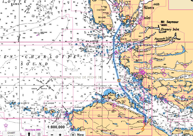
Today our destination was Port Hardy, jumping off point to crossing Queen Charlotte Sound, one of the two major open ocean crossings that we had to make.

Here is a map snippet of the 52 nm route:


At over 50 nm it was to be a relatively long day for us, and I wanted to be in the marina early enough in the day to get fuel and to have someone still be in the office.  That meant we had to have an early departure.

We pulled out a little before 6 AM.

The mornings this time of year are still a little cool, and there is no heat on the fly bridge, so today I ended up wearing my goose down vest for a few hours until it started to warm up a bit.

On the way the Alaska state ferry Malaspina passed us.
They were probably headed to Ketchikan.


We had favorable currents most of the way so we were making good time, until the tide turned and the currents were then against us.

Once we got to Queen Charlotte Strait the waters were very calm, smooth running, which we like.

We arrived at the QuarterDeck Marina in Port Hardy at about 1:15 PM.
We took on some fuel before moving over to the guest dock.

Here is a link to their website:
QuarterDeck Marina

430 nm to this point - finally over halfway home!

We stayed here one night on the south bound trip last summer and enjoyed it.
They have a nice facility and Lisa was able to take a taxi to a nice grocery store to replenish our supplies.

I may have mentioned previously that one of the aspects of last year's trip that made it less enjoyable than it could have been was the issue of getting accurate and timely weather forecasts, most especially for Queen Charlotte Sound and for Dixon Entrance, the two open ocean crossings that are required.

I took a couple of steps in order to address this issue.
First Bank graciously gave me a new Iridium Extreme satellite phone as a retirement gift.
I purchased an Iridium Axcess Point WiFi device that is designed to integrate with the sat phone.
Plan A was to use this arrangement to download what are known as GRIB files which contain weather data.

From Wikipedia:

GRIB (GRIdded Binary or General Regularly-distributed Information in Binary form) is a concise data format commonly used in meteorology to store historical and forecast weather data. It is standardized by the World Meteorological Organization's Commission for Basic Systems, known under number GRIB FM 92-IX, described in WMO Manual on Codes No.306. Currently there are three versions of GRIB. Version 0 was used to a limited extent by projects such as TOGA, and is no longer in operational use. The first edition (current sub-version is 2) is used operationally worldwide by most meteorological centers, for Numerical Weather Prediction output (NWP). A newer generation has been introduced, known as GRIB second edition, and data is slowly changing over to this format. Some of the second-generation GRIB are used for derived product distributed in Eumetcast of Meteosat Second Generation. Another example is the NAM (North American Mesoscale) model.

GRIB files can then be overlaid onto my Coastal Explorer navigational charts thus giving me the up to date detailed weather information that I needed.

Or so that was the theory.

Once I started on the task of actually making it work I ran into difficulties.
I was indeed able to download GRIB files via the sat phone, but they just didn't provide the level of detail that I needed when applied to the Coastal Explorer charts.

So then we came to Plan B, which was to acquire the services of a professional weather router.

A "weather router" is a person, or a company, that specializes in providing detailed weather information for cruising boats at any location all over the world.  In most cases weather routers are used for long off shore ocean crossings, such as crossing the Atlantic.  But they are service providers and if you are willing to pay the fees, they will provide the service.

I researched them and quickly came up with Ocean-Pro Weather & Routing:


Robert Cook,   Weather Router
Ocean-Pro Weather & Routing
Naples, FL:          239-775-7435
Cell Phone:         239-877-4094
Skype name:         captcookusa


I made initial contact with him very early in the process.
I was required to fill out a long survey which provided him the information he needed about the boat and its speed and capabilities, the crew and their capabilities, the location of the intended voyage, and all the contact information that we would need in order to facilitate communications between us.

I had been keeping Bob updated each night as to our location by way of the Spot Messenger.
He was on the recipient list, so each night when I fired it up to report our position, he was then informed of where we were.
We also stayed in touch via e-mails, which I could pull in whenever we had WiFi service, or via the sat phone e-mail when we were out of regular Internet services.

So now was Bob's time to shine.
My question to him was, "When is the best time for us to make the Queen Charlotte Sound crossing, and make it in such a way that it is enjoyable, and not just survivable?"

His response was that the very next day would be fine for us to cross.
So that was the plan then.

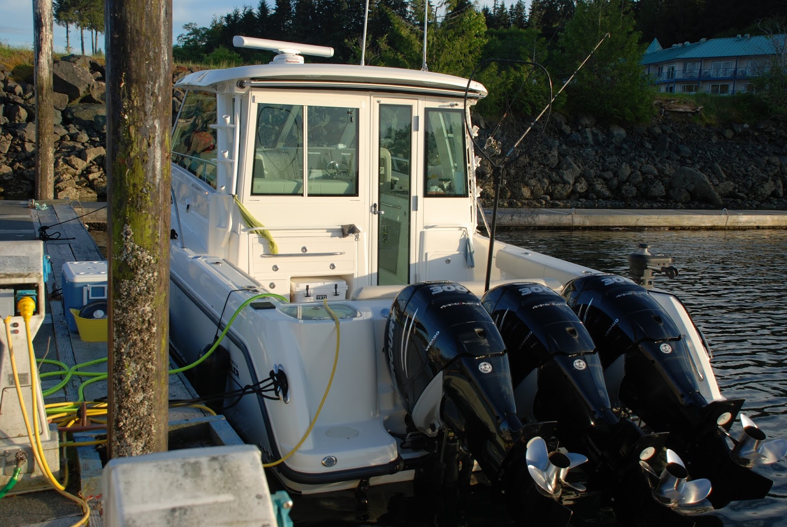
Here are some photos we took from around the marina.


This boat was moored near us on the guest float.
Note the horsepower - 300 HP times 3!
Also, you can't see it from the photo, but these are joystick controlled engines.
That means they all turn independently under computer control, which allows the boat to skid sideways, or hold position, all under one hand joystick control, and with no bow or stern thrusters.

There was a young Japanese couple on board, and the young woman was out on the back deck when we walked by.  I commented "That's a lot of horse power," to which she replied "Not working."
We discovered over time that she spoke only a little English, and her husband apparently spoke none.

A mechanic came by and worked on the engines and later on they were both all smiles as he left, so I assumed that now they were working.


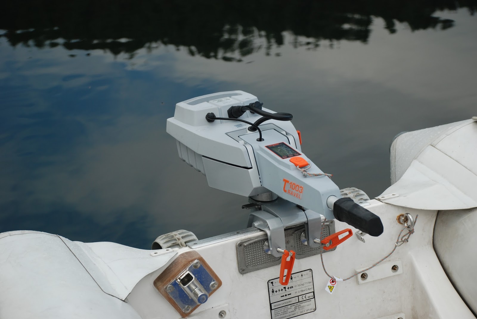
Another beautifully appointed Ranger Tug.

Faraway on the guest float


Beautiful sunset in the harbor

Trusting in Bob Cook's weather forecasting abilities allowed me to get some sleep this night, rather than worrying all night about getting a pounding the next day as we crossed Queen Charlotte Sound.